I finally finished a "study" job that took me a long time.
Thanks to the text "Craters of the Near Side of the Moon" and to Virtual Moon Atlas, I was able to give an insight that this shot deserved.
I can say that this area was practically unknown to me before this shooting.
After taking a look at it during the stacking phase, I must say that I fell in love with it.
I enclose here the text of the "notes aloud" that I transcribed while I was analyzing the area.
I remain convinced that there is still a lot to investigate.
I wish a good reading to those who will have the patience to continue.
In the night between 9 and 10 October 2020 I was lucky enough to have a good window of clear sky combined with decent seeing.
Our natural satellite was only 27° high from the local horizon and, despite this, I was able to obtain good images of the most significant areas of this colongitude.
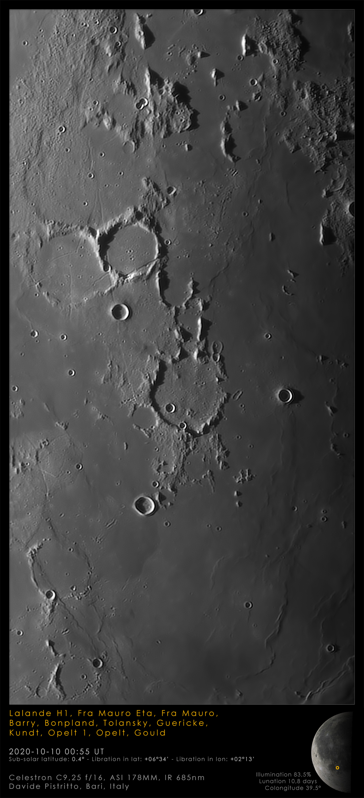
In this lunar picture I report lunar portions of considerable interest.
The area marks the northern border of the Mare Nubium with the southern one of the Mare Insularum. It is characterized by an important ejecta work from the Imbrian period.
The pivotal area, represented in this image in the center of the frame, sees the presence of four craters almost submerged by lava activity, each of which denotes interesting features.
These are the great Fra Mauro (96 km), Parry (47 km), the ghost Bonpland (59 km), and Guericke (60 km).
It is from Fra Mauro that the 45kg of lunar material recovered on the occasion of the Apollo 14 mission comes. Thanks to these, we were able to date the impact that occurred about 3.9 billion years ago.
The bottom of Fra Mauro is only 800 meters deep compared to its walls partially obliterated by the lava ejecta. And totally in its eastern part.
In its central area, however, it is crossed by a system of three rimae. One of these continues towards Bonpland while the other flows into Parry, from which this rimae system takes its name.
And the fact that the rimae themselves cut the slopes of the craters reveals their age, younger than the craters themselves.
Parry E, a small crater on the western edge, interrupts the rima. Parry E, therefore, is undoubtedly younger than the same rima.
If the remaining cirque of the crater is evident of Parry, the same cannot be said of Bonpland, the immediately adjacent crater to the west. In the southern part, in fact, Bonpland is for the most part first immersed in lava and then bombarded by at least 23 craters.
To the east of Parry, ruins of other craters are still evident. The one adjacent to him is Parry M showing only the east and west walls.
Outside the theater of those intent on playing hide and seek under the lava, remains outside, and beautiful in sight, the Tolansky crater, 13km wide whose perfectly circular borders are interrupted only by a very small impact on the outer edge of the western wall of this crater. This gap is also clearly visible on the shadow cast on the bottom of the crater in my image.
The quartet closes, perhaps, the most spectacular of all: Guericke with its continuous indentations hosts inside (in the north-west area) a small, rather pointed dome. And also on the outside, still to the north-west, another dome is clearly visible, this time characterized by an area with a lower albedo than the immediate lunar surroundings.
If the area around Guericke is so full of irregularities smeared on the lava, the one visible in the upper part of my image gives even more amazement.
The system of mountain peaks just north of Fra Mauro, in fact, is breathtaking. Here you can see Fra Mauro Eta, a mountain that extends for 20km in width in a north-south direction.
Continuing towards the edges of the photograph, to the east (and just to the south) another dome is visible that Virtual Moon Atlas does not report.
This is Lalande H 1.
To close, even the southern area of the image is no less interesting. Opelt and Opelt 1 are half-siblings linked only by their surname. In fact, if one is a phantom crater, the other is reported by Virtual Moon Atlas as a dome but which, in reality, should be a 57km area connected to a high past volcanic activity.
The train of the Gould formations closes, the last remnant of the war also swept away by lava.