Identifying the peaks of Montes d’Alembert
2022 April 6
The Montes d’Alembert are a chain of mountain peaks found along the western lunar limb. The individual mountains were grouped into a Montes by Schröter in 1791 and were named after the French mathematician, philosopher and physicist Jean le Rond d’Alembert. About 175 years later, Lunar Orbiter images showed that the mountains are part of the complex landscape that is the result of the Orientale impact. Therefore, in 1970 the name Montes d’Alembert was dropped as official IAU nomenclature. There persists some indistinctness in lunar literature as to what the Montes d’Alembert represent. The aim of this paper is therefore to identify exactly where the peaks are on the lunar surface. It is found that the inner and outer Montes Rook, the Montes Cordillera and the radial facies of the Hevelius Formation all contribute. Libration dictates which peaks can be seen.
Montes d’Alembert
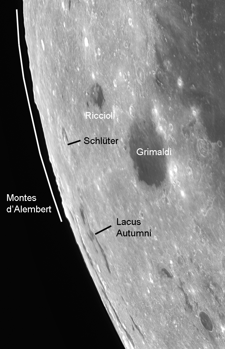
Between 5°N to 10°S latitude, a number of distinctive mountains can be seen along the western lunar limb that stand out against the dark background sky (Figure 1). This is roughly the area west of Grimaldi, Riccioli and Hevelius. Johann Hieronymus Schröter (1745–1816) was the first to depict the contours of these peaks along the lunar limb.1 In his Selenotopographische Fragmente, Schröter gives drawings of the mountains made under different libration circumstances and even silhouetted against the Sun’s disc during an eclipse.2,3 He collected the peaks under one name: Montes d’Alembert.
Observations of the Montes d’Alembert area are highly dependent on libration circumstances.4 This means that translating what was seen in the telescope to geological structures was difficult, especially at a time when lunar geology was in its infancy.1 It took the rectification of limb-region images and the trained eyes of geologists to identify an impact basin along the western lunar limb.5 This basin, the Orientale basin, was dramatically depicted in 1967 by Lunar Orbiter 4. It became clear that the mountains of Montes d’Alembert are not related to each other such that they form one mountain range. Instead, they are individual peaks that belong to the northern part of the Orientale multi-ring basin. Therefore, in a 1970 meeting, the IAU dropped the name, which had only been officially adopted in 1964. The reason was that ‘certain previously named features, especially those on or near Mare Orientale, proved to be non-existent’.6
However, the mountain peaks are there and can be clearly observed along the lunar limb. Therefore, the motivation of this paper is to identify where they can be found on the lunar surface and what their positions are, in the context of the Orientale basin.
Some indistinctness remains in lunar literature regarding these mountains, specifically about their heights and locations. Neison (1876), for instance, described the Montes as ‘a chain of considerable mountains rising in places nearly 20,000 feet above the surface’.7 Based on observations made by Mädler, he calculated that the slopes have ‘a steepness of perhaps 25° in parts’. This quoted height estimate is often copied by others: for instance, by Wilkins & Moore (1958), Price (1988), Wlasuk (2000) and Garfinkle (2020) to mention a few.8,9,10,11 Moore says that ‘some of its peaks may exceed 20,000 feet, but so far there are no reliable measures’.12
There is also no consensus on the exact locations of the mountains on the surface and most of the authors remain vague on this topic. To come back to Neison, he thought he was looking at the border of ring plains beyond Riccioli.7 Of course, the concept of impact basins was unknown at that time. Patrick Moore gave that the mountains are associated with the Mare Orientale complex, whereas John Moore believed that most of these peaks belong to the Montes Cordillera.13,14 Garfinkle stated that they can be attributed to the rims of the craters Schlüter and Hartwig.11
John Moore was the only one, until now, to make an attempt to pinpoint the exact locations of some of the peaks.14 He reconstructed the view of Schröter’s only dated drawing using the Lunar Terminator Visualisation Tool with the Kaguya global digital elevation model.15,16 Of the three peaks indicated by Schröter, the inner and outer Montes Rook and the area north of the Montes Cordillera could be assigned one peak each.
Observations
In recent years, the author made 10 images of the western lunar limb region under different libration circumstances. The images were made with a Celestron C8 ƒ/10 Schmidt–Cassegrain telescope. On 2011 Oct 14, 2011 Oct 15 and 2015 Mar 6, a Philips PCVC740K ToUcam PRO camera was used. On 2018 Sep 25, 2019 Dec 22, a ZWO ASI 290MM camera was used, whereas on 2018 Sep 2, 2018 Oct 27, 2018 Nov 23, 2020 Jan 12 and 2020 Apr 9, the ASI 290MM was used in combination with a ×1.5 Barlow lens. All observations show the area under a high sun.
Counting the number of mountains
Schröter and Wilkins present drawings under a number of observational circumstances and both identify quite a few individual mountains.2,3,4 However, it is impossible to correlate the mountains on different drawings with each other. The 1946 version of Wilkins’ 300-inch map depicts seven mountains (Figure 2).17 Wilkins & Moore (1958) give that ‘to the east of Riccioli are three peaks and a remarkable table-like mountain a little farther to the north’.8 The ‘east’ direction predates of course the current 1961 IAU convention of east and west, so the three peaks most probably relate to those indicated with β on the map by Wilkins (Figure 2). Alternatively, they could also be the three peaks that are drawn more towards the south (b and ε), since α (to the north) most probably represents the table-like mountain.
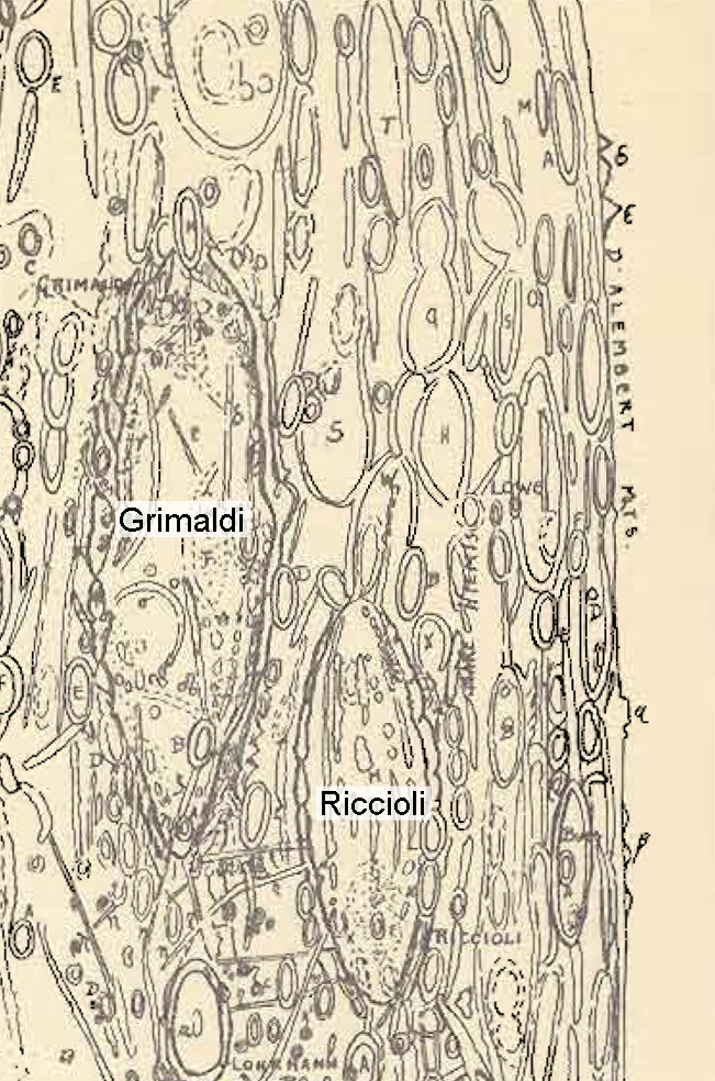
Figure 3 shows the author’s 10 images, arranged according to the location of the lunar limb that is maximally tilted towards Earth. They range from the northwestern limb region (2021 Oct 27), over the southwestern limb, towards the southeastern limb region (2020 Apr 9). The area between roughly 5°N to 10°S in latitude is shown. More irregularities of the lunar limb can be seen towards the north and south, but these fall outside the range defined as the Montes d’Alembert.
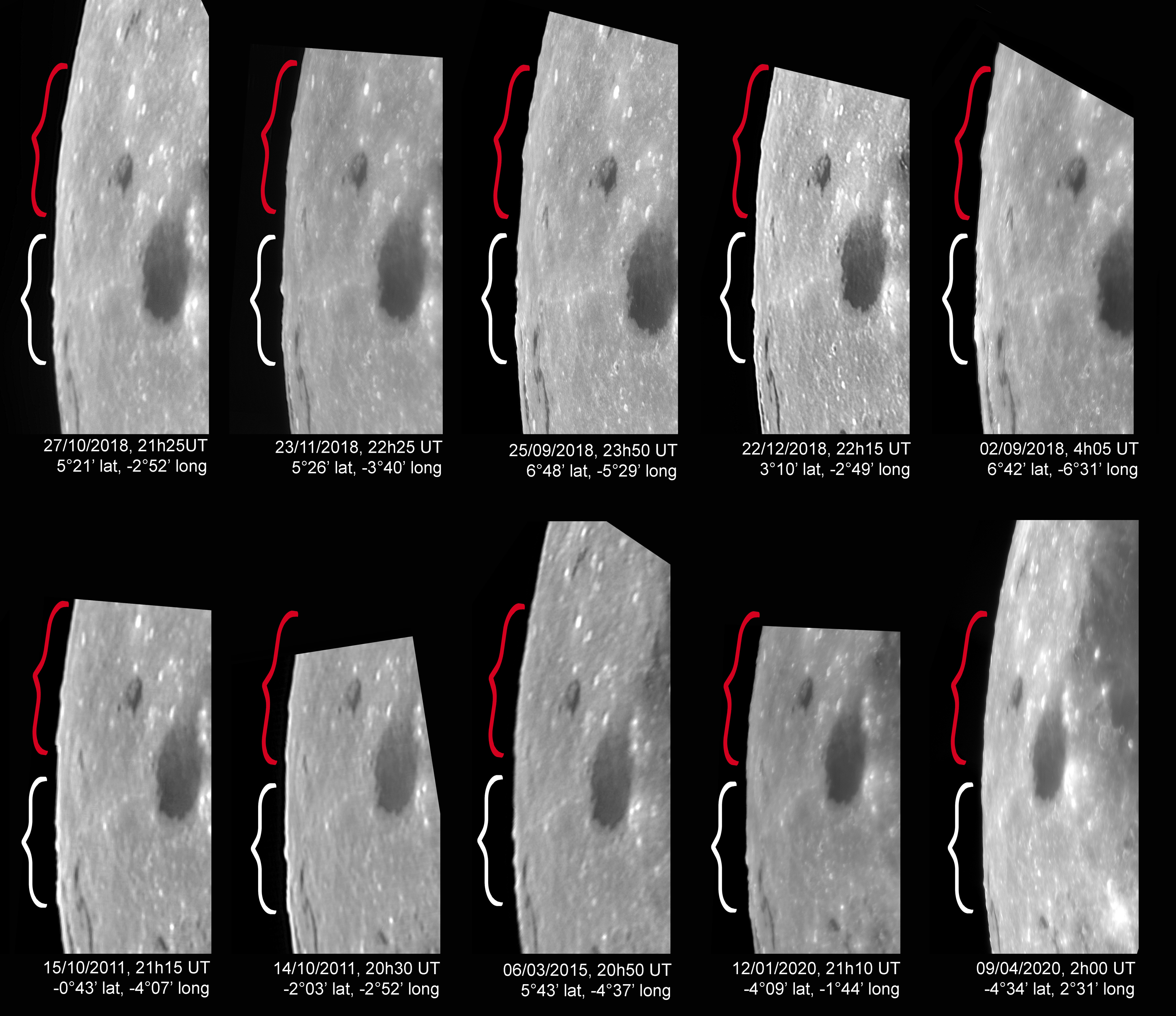
These images show a number of different mountains. As is the case on the drawings made by Schröter and Wilkins, it is difficult, not to say impossible, to correlate the peaks on the different images with certainty. The exact libration circumstances define which mountains can be seen, as was already the conclusion of Wilkins.4 However, it is possible to divide them, using the crater Schlüter as a border, into two groups. The first, here referred to as the southern group, is found south of Schlüter and accords with the three peaks that Wilkins indicated with b and ε.17 The second, here called the northern group, corresponds with the four peaks indicated with α and β.17
(Login or click above to view the full illustrated article in PDF format)
| The British Astronomical Association supports amateur astronomers around the UK and the rest of the world. Find out more about the BAA or join us. |