Lunar domes near Lavoisier K
2022 April 6
In this study, we examine four lunar domes located near the crater Lavoisier K. The large domes, termed Lavoisier 1–3, have diameters of over 25km, with linear rilles traversing their summits and slopes of between 0.5° (Lavoisier 1–2) and 0.7° (Lavoisier 3). Another lunar dome, termed Lavoisier 4, has been identified using telescopic imagery, while in LROC WAC imagery it is not apparent. It has a base diameter of 5.7km and a height of only 40m, resulting in a slope angle of 0.76°. Based on rheologic models, we infer the physical conditions under which the examined domes were formed. The main goal of this paper is to promote serious lunar research among dedicated amateur astronomers who are interested in observing and imaging the surface of the Moon, as well as in its geological history. In combination with high-resolution spectral analysis techniques, such investigations might extend our present knowledge of the processes that formed volcanic edifices on the Moon.
Introduction
Comprehensive study of lunar domes is possible, based on images of the lunar surface acquired under oblique illumination. These conditions enable measurements to be made and maximise the detail recorded. Most apparent lunar domes are discernible in the topographic maps acquired by the laser altimeters LALT and LOLA, on board the Kaguya and Lunar Reconnaissance Orbiter (LRO) spacecraft. However, they cannot be unambiguously identified as lunar domes based on such data alone. As a consequence, ground-based images obtained using telescopes and cameras like those commonly used by well-equipped amateur astronomers are of great value for the morphologic and morphometric analyses of lunar domes.
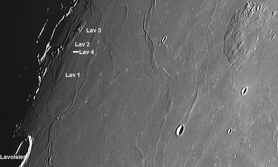
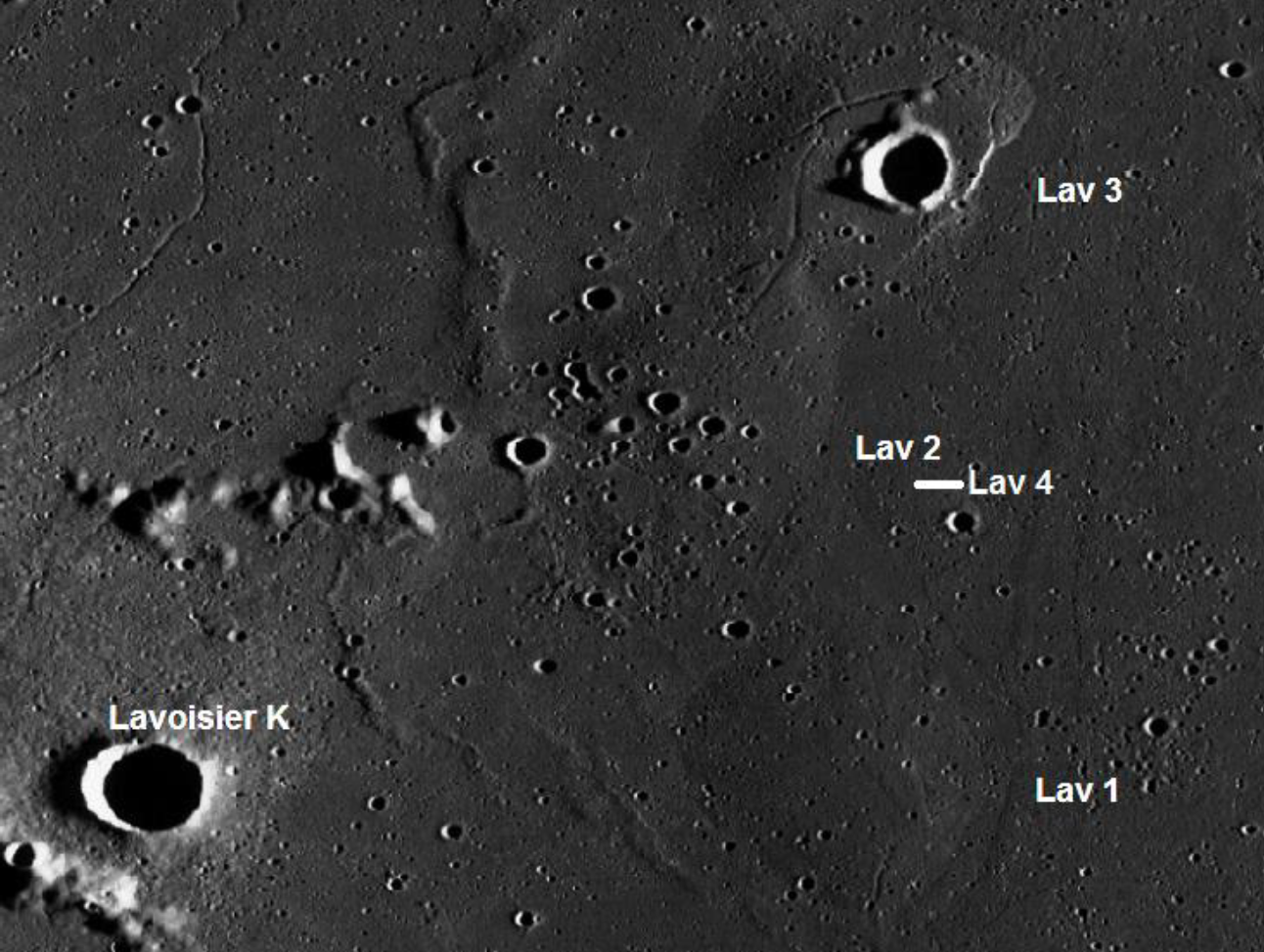
C. Pau has imaged four volcanic domes, located near Lavoisier K (Figure 1). The LRO Wide Angle Camera (WAC) image shown here (Figure 2) displays the large and elongated domes termed Lavoisier (Lav) 1–3. In this image, the shallow dome Lav 4 is not as prominent as in the telescopic image (Figure 1). Associated topographic profiles of each examined feature were extracted from the LOLA DEM dataset, using the ACT-REACT QuickMap LRO global basemap (target.lroc.asu.edu/da/qmap.html). However, due to their low slope, the 3-D reconstructions generated using QuickMap did not allow satisfactory results (Figures 5a–b & 16a–b). Therefore, we have obtained the 3-D reconstructions of Lav 1 and Lav 4 using photoclinometry and shape-from-shading (SfS) techniques.1 These make use of the fact that surface parts inclined towards the light source appear brighter than those inclined away from it. The iterative scheme used for photoclinometry and the SfS approach, applied to terrestrial telescopic images, is described in two of our preceding articles published in the Journal and it is not repeated here.2–3
The height, h, was obtained by measuring the altitude difference in the reconstructed 3-D profile between the summit and the surrounding region, taking into account the curvature of the lunar surface. The average flank slope, ζ, was determined according to: ζ = arctan 2h/D, where D is the diameter in kilometres. The morphometric properties of the examined domes are reported in Table 1.
Spectral results were obtained using the Chandrayaan-1 Moon Mineralogy Mapper (M3), an imaging reflectance spectrometer that can detect 85 channels between 460 and 3,000nm,4 and the Clementine UVVIS and NIR reflectance data.
Finally, the primary goal of this study is to demonstrate that high-resolution telescopic imagery of the elusive lunar domes is useful for the recognition of non-cataloged examples.
Results & discussion
The Lavoisier domes combine to form a broad-but-low ridge, some 70km long from north to south, with Lav 3 forming the northernmost part and Lav 1 the southernmost. To the east of the complex is a moderately conspicuous wrinkle ridge that runs in an ‘S’-shaped curve between the craters Lavoisier A and Harding, whilst to the west are the highlands of the western limb. The region has been subject to both volcanic and tectonic forces, which typify geological processes around mare margins.
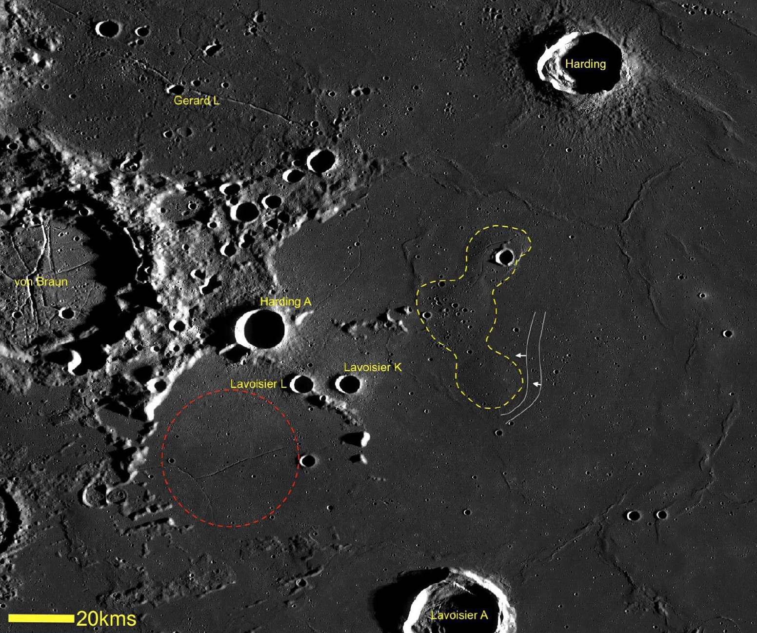
Extensive volcanism is evident in the form of the numerous floor-fractured craters (FFCs) such as von Braun and Lavoisier (and its numerous smaller neighbours) to the west, and tectonism in the form of the complex wrinkle ridges produced by compressional forces within the Procellarum Basin to the east. These tectonic forces, generated by the subsidence of the central Procellarum Basin, are also responsible for two extremely low-amplitude scarps visible immediately to the east of the Lavoisier domes. These scarps can be seen to almost ‘wrap around’ the southeastern margin of Lav 1 (Figure 2 & 3), which suggests that the dome complex predates the subsidence within the Procellarum Basin and the eruption of the surrounding mare lavas.
The domes Lav 1–3 are of elongated shape and large diameter, displaying linear or curvilinear rilles which are the surface expressions of tensional stresses.5–6 Furthermore, their surfaces merge smoothly into that of the surrounding mare and in the case of Lav 3, the dome outline is limited by a fault.
Intrusions are subsurface concentrations of magma that have locally uplifted the mare but have not erupted. This is a mechanism reported for terrestrial laccoliths.
Laccoliths are shallow magmatic intrusions which lead to the vertical displacement of the overburden, creating a characteristic dome-like topography at the surface. Laccoliths have recently been proposed to explain various geological features such as domes or floor-fractured craters on the surface of the Moon, as well as Mars and Mercury.7 Johnson & Pollard (1973) recognise that laccolith formation is characterised by three distinct stages.8 During the first stage, a thin sill-like unit undergoes lateral growth. The second stage consists of vertical growth caused by flexure of the overlying strata due to the pressurised magma. If the flexure-induced vertical uplift exceeds a few hundred metres, piston-like uplift of a fault-bounded block may occur during the third stage of laccolith formation. Hence the magma accumulating beneath the surface produces not only an upbowing of the surface rock layers but also failures in the rock strata (fracturing).1
A reliable discriminative criterion is the circularity of the dome outline: the putative intrusive domes are elongated and have low slopes (< 0.9°). Class In1 comprises large domes, with diameters above 25km and flank slopes of 0.2–0.6°, with linear or curvilinear rilles traversing the summit. Class In2 is made up of smaller and slightly steeper domes, with diameters of 10–15km and flank slopes between 0.4 and 0.9°. Class In3 comprises low domes with diameters of 13–20km and flank slopes below 0.3°.
The domes Lav 1–3 (Table 1) hence match the properties derived for a putative intrusive dome belonging to class In1,1 and could imply an origin due to a subsurface intrusion of a large magmatic body.
Lav 1 is an elongated swell with a base diameter of 20 × 25 ± 0.3km and an elevation of 100 ± 10m (Figures 5–6), yielding an average slope of 0.52 ± 0.05°.
Lav 1 is the most obvious of the four domes, having a distinct sub-circular outline and extensional fractures which are mainly concentrated along the eastern half of the dome. These fractures are of low visibility, but the most prominent has a maximum width of approximately 200m and a depth of between 10 and 20m (Figure 4). Where this prominent fracture crosses from the dome to the mare surface to the south, it transforms from a trough to a ridge a few metres high, that can be traced in a roughly straight line for 7km. This curious transformation could be related to the presence of an intrusive dyke which is responsible for both the fracture and the ridge, but this must remain in the realm of speculation.
The fractures on Lav 1 appear to be infilled in places, which could be regarded as evidence of lava flows and effusive volcanism. One section of the main fracture system where infilling is conspicuous is located near a 90° dog leg, where the fracture angles abruptly to the north, and just south of where it divides into eastern and western arms. There is a suggestion in this area of a lower-albedo surface with a low lobate margin (Figure 9), which may represent a thin lava flow. The available imagery is however inconclusive, and any identifications of lava flows must be regarded as tentative at best.
A more confident identification is that of a number of irregular mare patches (IMPs), associated with this fracture and the eastern branch north of the 90° dog leg. These IMPs are primarily associated with the rims and inner walls of small impact craters in the < 500m size range (Figure 7). Some smaller IMPs can be found within the fracture itself, especially along its edges and on the floor. These take the form of bright concentrations of boulders set in small, irregularly shaped depressions with sharp boundaries, outside of which is the darker surface of the dome.
The IMPs on Lav 1 range in size from a few metres up to several tens of metres across. Where they are associated with craters, they are typically found just inside the rim and in arcs of varying length around the circumference. This type of distribution is seen at other locations on the lunar surface, where IMPs are associated with small craters.9
(Login or click above to view the full illustrated article in PDF format)
https://britastro.org/wp-content/uploads/1970/01/fig-1-1.bmp
https://britastro.org/wp-content/uploads/1970/01/fig-2-1.bmp
https://britastro.org/wp-content/uploads/1970/01/fig-3-1.bmp
| The British Astronomical Association supports amateur astronomers around the UK and the rest of the world. Find out more about the BAA or join us. |