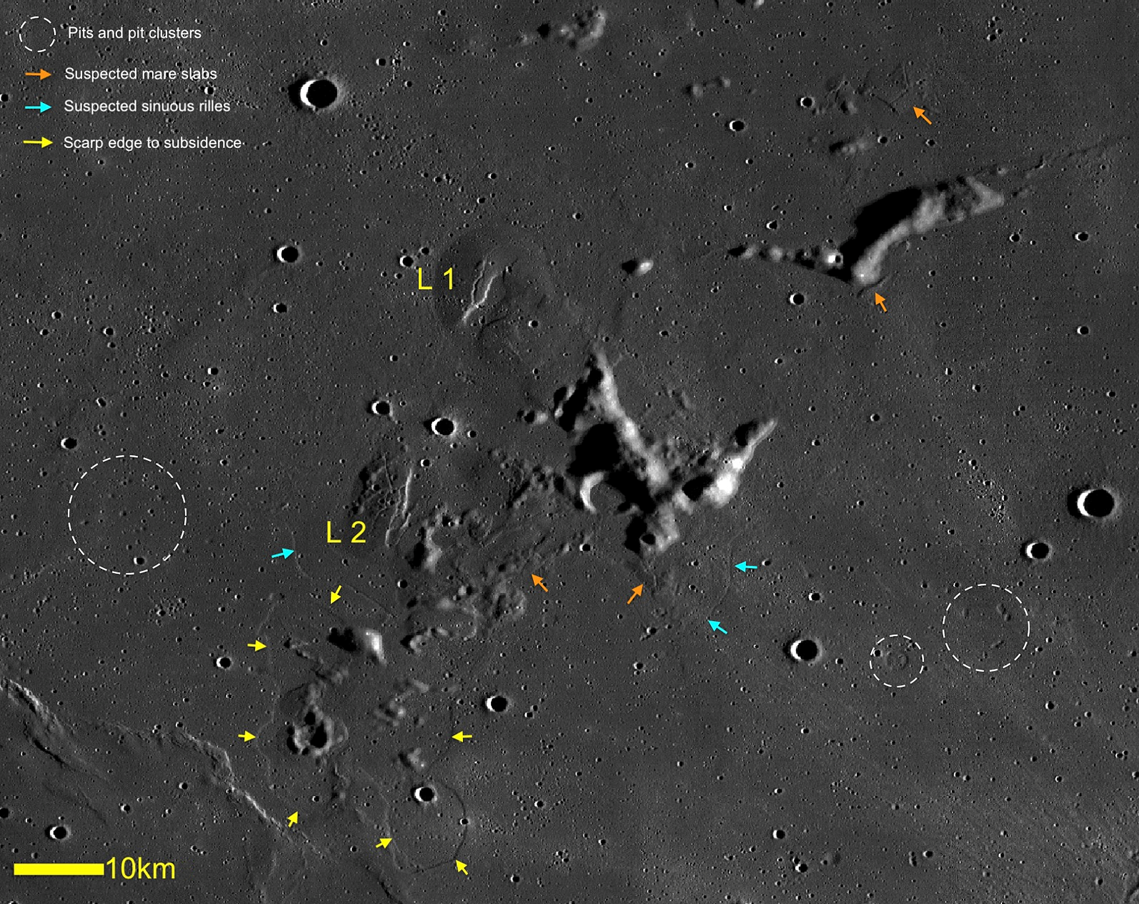
Lunar volcanic complex north-west of Lichtenberg
2023 February 7
In this article, we examine two dome-like features which we identify as Lichtenberg 1 and 2, located in Oceanus Procellarum and approximately 115km to the north-west of the crater Lichtenberg. The mare surface surrounding these domes exhibits landforms suggesting that the lavas forming the vast plains subsided once a cooled and rigid upper crust had formed, but before the complete magma pile had an opportunity to solidify from the molten state. Mobility within this still-molten core resulted in migration from some areas, leaving the overlying crust unsupported and prone to collapse either locally, in the form of pits, or on a larger scale. Morphological data are combined with spacecraft data, telescopic imagery, photoclinometry and spectral data to produce a model for the formation of the Lichtenberg domes as laccolith-type structures with evidence for effusive volcanism also being identified, suggesting that this apparently insignificant region played an important role in the evolution of the surrounding lunar surface.
Introduction
In this paper, we examine the morphometric, morphological and spectral characteristics of two elongated features located 115km north-west of the crater Lichtenberg (Figure 1). They are characterised by faults on their surfaces with linear or curvilinear rilles crossing their summits, indicating structural control by subsurface processes.
Features such as these are commonly interpreted as resulting from flexural uplift of a rigid overburden due to subsurface magmatic intrusion, and whilst both Lichtenberg 1 and 2 (L1 and L2) have apparently experienced an episode of inflation as a result of this, the surrounding mare surface displays many indications of a drop in level. This takes the form of either large-scale subsidence features in the order of several kilometres in extent, or small-scale collapse features such as pits, which are generally in the sub-kilometre size range, but are often clustered together into groups over a wider area.
In addition, a number of the highland peaks that protrude above the mare surface are fringed by slab-like sections of mare basalt which may represent the remnant of the solid crust formed over newly erupted mare lavas, which became stranded as the mare level fell locally. This may have happened in a manner similar to icebergs becoming stranded on a shoreline as the tide recedes. There are some features visible in the area of the domes that may represent partially submerged sinuous rilles, but their identification is tenuous as they are extremely subtle in nature, and neither origin nor terminations can be identified.
Morphometric properties of Lichtenberg 1 & 2 (LOLA DEM dataset)
The new global topographic map of the Moon obtained by the Lunar Reconnaissance Orbiter (LRO) is the principal source of topographic information used in the study of L1 and L2. Both have a non-circular outline that can be described by a major axis a and a minor axis b. We define the average dome diameter as the geometric mean D = (ab)1/2 and their circularity as c = b/a. The average flank slope is defined as ξ = arctan (2h/D), where h is the height.
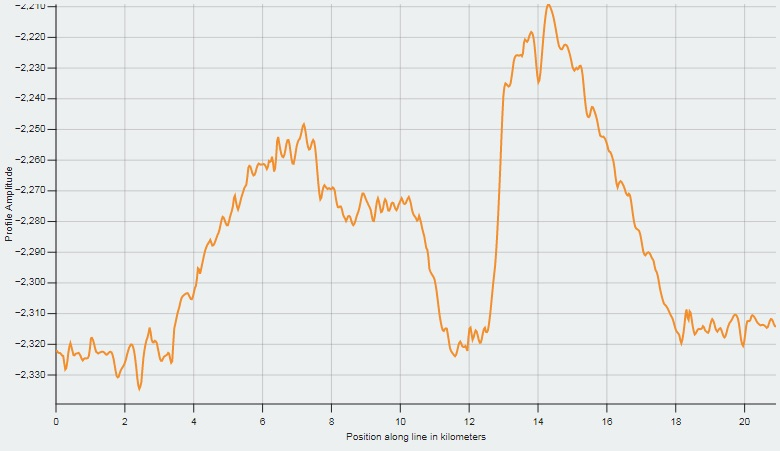
Associated topographic profiles were extracted using the LRO Camera (LROC) QuickMap global basemap. L1 has a base diameter of 25 × 14 ± 0.3km and a height, determined using the cross-sectional profile in the E–W direction, of 115 ± 10m, with the average slope angle corresponding to 0.65 ± 0.1° (Figure 2). L2 has a base diameter of 26 × 20 ± 0.3km, a height determined using the cross-sectional profile in the E–W direction to be 135 ± 10m, and an average slope angle corresponding to 0.6 ± 0.1° (Figure 3).
Digital elevation map based on telescopic imagery
To determine the morphometric properties of the examined domes, we also make use of an image-based 3-D reconstruction approach which relies on a combination of photoclinometry and shape-from-shading techniques.1,2 This method takes into account the geometric configuration of camera, light source, and the surface normal, as well as the reflectance properties of the surface to be reconstructed. The height h of the dome was thus obtained by measuring the altitude difference in the reconstructed 3-D profile between the dome summit and the surrounding region, taking into account the curvature of the lunar surface.
The 3-D reconstruction of L1 and L2 (Figure 4) was produced using the telescopic image shown in Figure 5, taken by Pau on 2017 Nov 2 at 13:36 UT.
Based on the photoclinometry and shape-from-shading techniques, the height of L1 is determined to be 110 ± 10m and L2 125 ± 10m, in accordance with the results obtained using the GLD100 dataset and LOLA DEM (Digital Elevation Model).
Shadow-length method
The height of L1 was also computed from Figure 5 using the shadow-length method, according to the relation h = l tan α, where l is the shadow length, corrected for foreshortening and measured in kilometres, and tan α the tangent of the solar altitude. This measurement was performed using the LTVT software package.3 A height of 110 ± 10m was obtained, in accord with previous results.
Spectral data & composition
Thermal emissivity data from the LRO Diviner instrument provides compositional information from three wavelengths, centred on 8µm, that are used to characterise the Christiansen Feature (CF), which is directly sensitive to silicate mineralogy and the bulk SiO2 content. For the study area, CF values of 8µm are towards longer wavelengths (8.3µm), indicating a less silicic and thus basaltic composition.4 In some regions the CF displays values of 8.55µm, suggesting possible olivine content. An average CF value of 8.16µm is consistent with a mixture of plagioclase and some pyroxene, while the average CF values of maria basalts range from 8.30–8.40µm. Based on Mineral Mapper reflectance data acquired by the JAXA SELENE/Kaguya mission and Moon Mineralogy Mapper (M3) spectral analysis, L1 and L2 display high abundance of the mineral olivine (Figure 6).
The mafic minerals (e.g., pyroxene and olivine) of mare basalts can be identified through their characteristic spectral absorption features, with pyroxene displaying two absorption bands at approximately 1,000 and 2,000nm, while olivine is revealed by a broad and asymmetric 1,000nm absorption band.5,6 The ‘secondary’ absorption near 1,250nm in the case of olivine allows its detection when admixed with the spectrally ‘stronger’ pyroxene, and is dependent on the relative abundances of both minerals. The spectra derived from the M3 dataset are reported in Figure 7. The shape of the absorption band near 1,000nm includes a combination of bands: low-calcium pyroxene (OPX), high-calcium pyroxene (CPX) and olivine.
According to the FeO and TiO2 content (~17wt% and ~1.2wt% on average, respectively) we can infer that the main rock type of the examined elongated domes is low-titanium basalt with olivine-rich composition. The absence of a spectral contrast with the surrounding surface indicates that L1 and L2 are not pre-existing elevated highland terrain, or kīpukas, which were later embayed by basaltic lava (such as Darney c in western Mare Cognitum),7 and confirms that they are mare-related structures of volcanic composition.
Topography
The most prominent volcanic structures in the study area are of course Lichtenberg 1 and 2, which are interpreted as domes caused by the subsurface intrusion of laccolith-type bodies. Both have a number of surface fractures which may have arisen by a combination of inflation from beneath and subsequent collapse. Lichtenberg 1 is the most regular in form, with an elongate-rounded planform and a prominent channel approximately 2km wide and 90m deep, leading radially away to the south-west from the summit. This channel is morphologically similar to examples seen in some terrestrial calderas, with one being Monte Epomeo on the island Ischia in the Bay of Naples,8 and another being Cumbre Vieja on La Palma. In these cases however, the channel is the result of flank collapse, with extensive debris aprons present on the adjacent sea floor. In the present case, there is no evidence of a debris apron associated with the open end of the channel, and the minimal slopes and height of the flank would argue against such gravity-induced instability. It might not be unreasonable therefore to interpret this as a lava outflow channel.
Carlino et al. (2006) explain the resurgence of Monte Epomeo by the thrust of a laccolithic intrusion of 10km diameter, located at a depth of 1km.8 The structure of the resurgent block is delimited by faults, indicating that the Monte Epomeo laccolith has undergone a piston-like uplift phase.
Two fracture systems cross the summit of L1, appearing to be associated with a collapse event as opposed to any tensional forces resulting from uplift. A tabular slab of the summit has separated along a prominent fracture and now lies tilted to the east at an angle of some 3°. This fracture appears to be one component of a larger rift system that traverses L1, trending in a SW–NE direction. This tilted slab has a number of fine arcuate fractures which are concave towards the east, and which can be traced as a curving line onto the dome surface to the east. These appear to define a caldera-like summit structure, noted above, which opens to the mare surface via the channel to the south-west.
The fine fractures must have formed prior to the collapse of the slab, indicating at least two phases of collapse: the first along the arcuate fissures to produce a caldera-like summit crater, and second along the major fractures which isolated the slab from the rest of the summit surface.
Evidence of some effusive activity in the form of three lower-albedo patches is visible on L1, associated with the caldera-like summit depression. These may represent pyroclastic deposits of some form. Two of the patches, A and B in Figure 8, are in all likelihood a single unit which has been divided in two by a line of younger Lichtenberg secondary craters. The northern margin of B has low-relief lobate margins of no more than a few metres height (Figure 9), with some of the lobes partially infilling small craters and embaying others. This would be consistent with its emplacement as a mantling of fine-grained pyroclastic material or thin lava. The third, apparently separate low-albedo area, C, can be seen approximately 3km to the east of B.
The spectra of these low-albedo patches display a broad absorption band over 1,000nm and a weak 2,000nm band typical of an olivine component (Figure 10). However, spectra of high-calcium pyroxene mixed with Fe-bearing glass can be virtually indistinguishable from common Fe-bearing olivine compositions.5,6 This effect, combined with the fact that Fe-bearing glass is generally much more difficult to detect than other ferrous minerals, may be causing glass occurrences on planetary surfaces to be underreported. Thus the localised deposits may represent a final volcanic product, slightly differing in olivine-rich basaltic composition, or may be constituted by Fe-rich glass material intermixed with basalts. These suspected pyroclastic deposits might represent the most visible remnants of late-stage eruptions that took place within the proposed collapsed summit ‘caldera’.
Lichtenberg 2 appears to be more extensively fractured, with sections to the east and west apparently having subsided and then been submerged by encroaching mare lavas (Figure 11). This has left an impressive east-facing scarp some 100m high on the eastern edge of the dome, giving an indication of the magnitude of vertical displacement involved. The fractures on Lichtenberg 2 may have formed during the laccolith phase of the structure, but the vertical displacements show that subsidence has also influenced the morphology of this dome. There are no obvious volcanic or effusive features visible, in contrast to Lichtenberg 1.
Extensive areas of mare surface to the south of L2 have subsided, to produce large depressions within which the surface level is some 10–20m lower than the surrounding mare (Figure 1). The areas are bounded by inward-facing curvilinear scarps that define largely circular depressions. In places, they appear to be deformed by a number of approximately NW–SE-trending wrinkle ridges. This shows that the subsidence pre-dates the compressional forces that produced the ridges. The depressions may have originated from the collapse of a solidified crust that had formed over the newly erupted mare lavas, as the underlying but still molten layer drained away by subsurface migration.
An alternative interpretation is that these depressions represent a former lava lakebed, and the surrounding scarp represents a shore-like feature. This interpretation is not considered possible in this case, as there is a lack of any conspicuous outflow channel or other erosional features usually encountered in drained lunar lava lakes.9–10
(Login or click above to view the full illustrated article in PDF format)
| The British Astronomical Association supports amateur astronomers around the UK and the rest of the world. Find out more about the BAA or join us. |