Mapping Radio Meteor Altitudes for GRAVES
Mapping Radio Meteor Altitudes for GRAVES
|
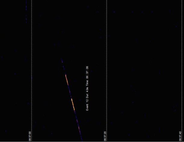
Background The Radio Meteor Detection collaboration Project has been collecting data from a number of contributors since 2017. One of our projects is to see if we can successfully match Radio and Video events to aid our understanding of meteor phenomena. To that end we are currently creating a Radio Map to establish those volumes of space where radio and video coverage overlap. Video recordings provide meteor event location and hence video coverage maps can be readily constructed. Video camera detection is seldom beyond a range of 250 km Netmode. For radio meteor observations, apart from a broad idea of the range of altitudes where they can occur, the location of the event is generally unknown. The GRAVES radar system near Dijon in France was designed to detect space objects in a wide arc, from due East through South to due West (see for example ) at elevation angles from 15° to 40°. Advantage is taken of this powerful transmitter for radio meteor detection and events can be detected from the radio observers across Europe. These meteor captures can be made for observers up to the radio horizon of meteor altitudes in the main (southern) beam. Many radio observers to the north of the Dijon line, indeed, some as far as the Scottish islands, detect very reasonable numbers of meteor events. At distances where the illuminated altitudes south of GRAVES cannot be “seen” significant numbers of meteor events are regularly recorded. It is therefore generally accepted that many meteor events arise from scattered radiation from the rear of the GRAVES transmitter. This extraneous radiation from back of the antenna panels will probably be reflected from the ground or from nearby control and power buildings to the rear creating an unpredictable pattern of illumination into the skies. Obviously, knowledge of these unknown radiation patterns will benefit attempts to match radio to video meteor observations; there would be no value trying to pair a video meteor in a known position if there is no radar signal in that area. In this Project we aim to measure the variation of the GRAVES signal in all directions by using the reflections from large radar targets where the position is accurately known. The ISS provides a large radar cross section and GRAVES reflections from it and are routinely detected amongst meteor events, as in the example below:
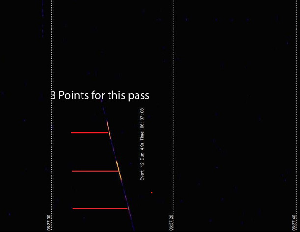
From observed times of radio detection, the latitude, longitude and altitude of the ISS can be obtained. It is then possible, in effect drawing a line from GRAVES to the ISS, to interpolate the position where the line passes through the start of meteor ablation altitudes at 120km. The ISS detection positions and interpolated meteor layer positions can then be overlaid on maps and the coverage areas built up. Additionally, the bearing and elevation from GRAVES can be determined, providing a more general view of the radiation pattern. The process Using “Heavens Above” we predict the time windows in the ISS orbits where it is above the horizon for each Contributor based on their location. The Contributor then reviews screen shots from Spectrum Lab and looks for any captures of the ISS between the predicted times. When a capture is found the contributor records the time or times of for each ping (see the example below). The separate pings may correspond to pulses from different sectors or directions of the GRAVES radar.
From these ISS coordinates and altitude and GRAVES coordinates, the corresponding coordinates of the 120km meteor ablation altitude is calculated. Ongoing Results We are publishing a number of Maps as follows The Group and Individual ISS Radio Maps plot the actual position of the ISS as detected by contributors. Contributor and ISS Plots are colour coded and additionally, if you hover over a circle, it will give more details The Group and Individual Meteor Radio Maps plot the calculated latitude and longitude of the 120km altitude where meteors could scatter radiation from GRAVES. The ISS radar map shows the extent of detections. At latitudes less than that of GRAVES, 47° N, the ISS will be in the stronger main beam. The latitudes greater than 47° are the unknown territory of particular interest to this project. The maximum latitude plotted on the ISS map is about 51.6° N corresponding to the most northerly extent of the ISS orbit. This implies the maximum latitude for points on the meteor map of 48.6°. To extend the meteor map to the north it will be necessary to apply the same process to other satellites. It is possible that detected ISS positions to the south of GRAVES corresponding to meteor altitude that would be below the horizon for some UK and northern European observers. As our data builds up we will overlay confirmed video detections. The areas where we have radio and video map overlaps are those where efforts can be made to tie together meteor events at specific times from the two detection techniques. If you want any more information or feel you can help in any way please do get in contact@radiometeordetection.org ©2020.All rights reserved. |
 Given a date and time of the captured pass we can look up the latitude, longitude and altitude of the ISS using the look up application at
 | The British Astronomical Association supports amateur astronomers around the UK and the rest of the world. Find out more about the BAA or join us. |