Juno at PJ57: Io
JunoCam at PJ57: Part I: Io
John Rogers (BAA) (2024 Jan.30)
Juno’s 57th perijove was on 2023 Dec.30, shortly preceded by its first really close flyby of Io, at an altitude of 1500 km. Thus JunoCam was able to take the first closeup views of the volcanic moon for 22 years, since the last successful Galileo Orbiter flyby in 2001 Oct.
There was much anxiety about PJ57 because at PJ56 (Nov.22), JunoCam developed a serious problem with the camera: intense streaky noise appeared all across the images. It was feared that this could be a permanent problem which would impair subsequent imaging, including of Io. However, the JunoCam team (particularly Malin Space Science Systems) managed to cure the problem by heating the camera to ‘anneal’ the CCD. The PJ57 images appear to be perfect. Full-quality images of Io have been posted on https://www.missionjuno.swri.edu/junocam/processing and www.unmannedspaceflight.com, and Io expert Jason Perry has posted informative comments on those forums.
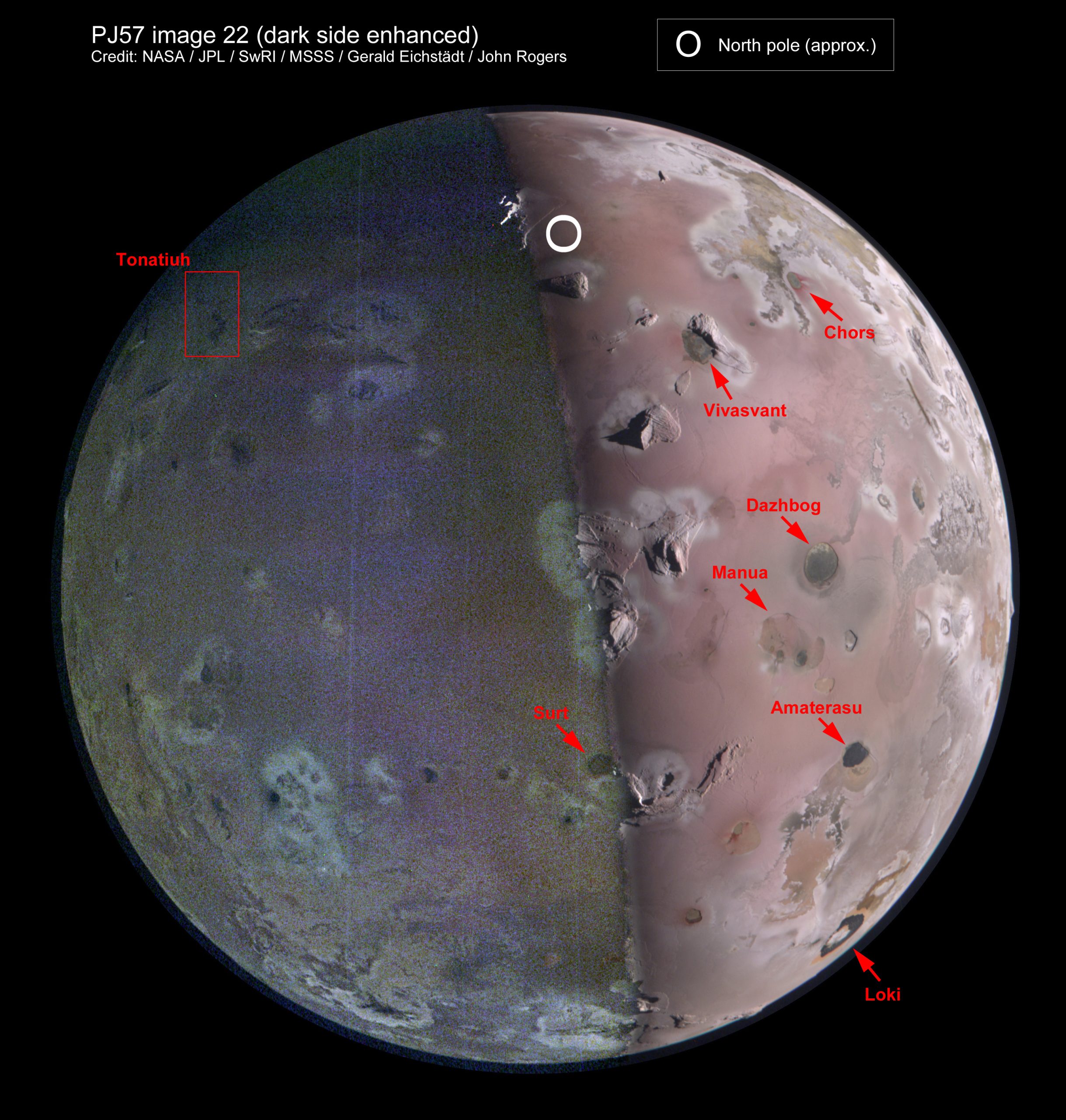
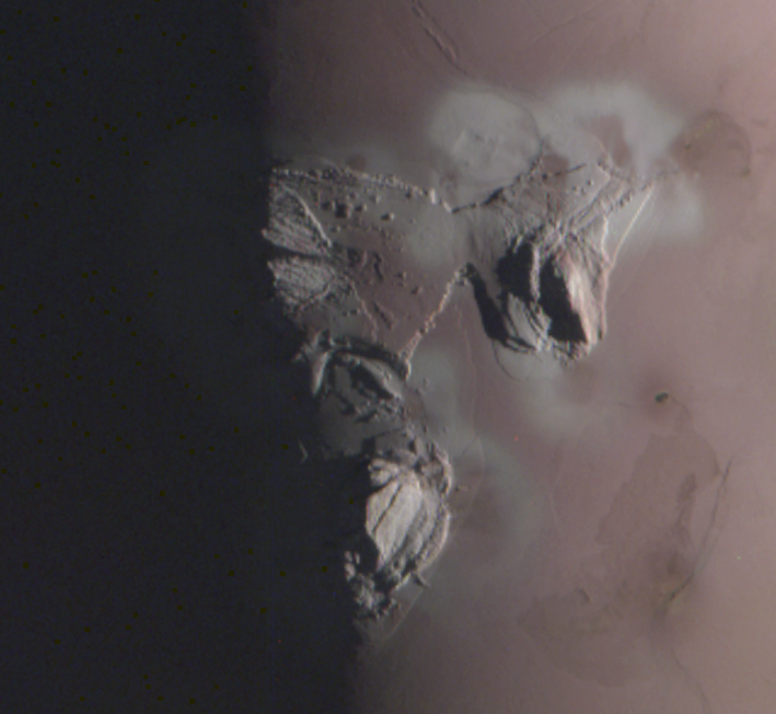
Juno came in over Io’s dark side, and imaging began as it passed onto the sunlit side over Io’s north polar region. So the first, highest-resolution image covered the north pole, and the subsequent images covered more of Io’s northern hemisphere as Juno rapidly moved away towards its pass over the north pole of Jupiter (Figure 1). Moreover, most of the “dark side” in these images was well illuminated by light reflected from the planet. So JunoCam completed the mapping of Io’s north polar region, partly at high resolution in sunshine and partly at low resolution by Jupiter-shine (Figure 2). Notably, it obtained the first good images of several impressive high mountains that had never been properly resolved before, and discovered one mountain very close to the north pole, at 85ºN. As is common on Io, some of these mountains have volcanic calderas alongside them. All the labelled calderas were hot spots in recent JIRAM images (e.g. PJ47; Figure 3A).
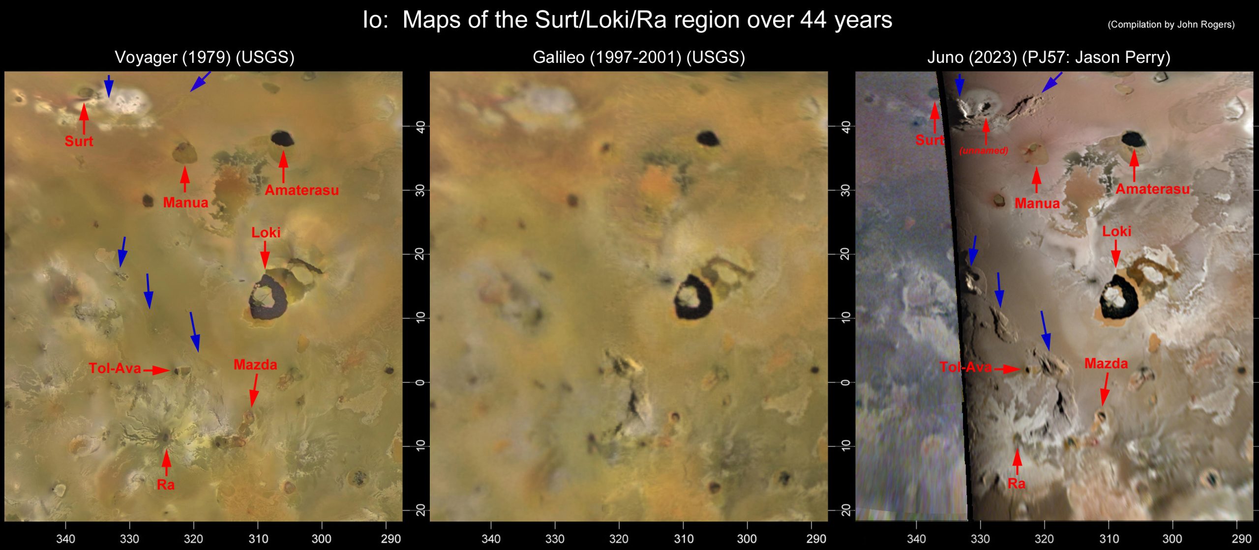
A global map from the PJ57 images is in Figure 4. The images are also very useful for mapping topography at lower latitudes, as previous missions rarely got extensive hi-res images near the terminator, so a lot of mountainous features were poorly known. The PJ57 map shows the relationships of mountains and volcanoes much better than the Voyager or Galileo maps (Figure 5).
No volcanic plumes were visible in the images, and there were no large changes since the Voyager and Galileo mapping. However, Io has ~100 infrared “hot spots” (volcanic calderas or active lava flows), and the PJ57 images showed local changes around some of these, including Chors, Tonatiuh, and Loki.
Further details are given in the full report, available here as a PDF: Report-on-PJ57_Io
The full-size figures are in this ZIP file: PJ57-Report_Io_Figures
Figure 2 & 5 are shown below:
| The British Astronomical Association supports amateur astronomers around the UK and the rest of the world. Find out more about the BAA or join us. |