- This topic has 8 replies, 4 voices, and was last updated 6 years, 2 months ago by
 Alan Snook.
-
AuthorPosts
-
9 December 2019 at 12:17 pm #574470
 Alan SnookParticipant
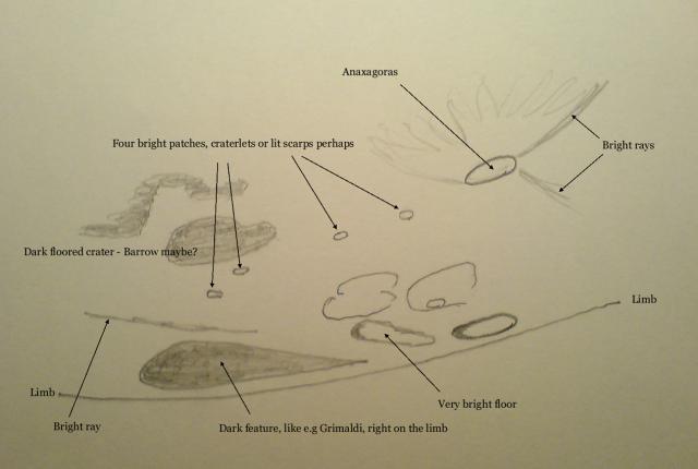
I’m working on the Astronomical League’s Lunar II programme. No.71 on the list is observe any polar crater with a latitide greater than 80 degrees. Libration in latitude was better than +6 degrees last night and I spent a long time picking over the area NE of Anaxagoras. However I am struggling to match my sketch with the annotated photo in S&T June 2017 page 53 and with my Hatfield Photographic Lunar Atlas (map2). The different lighting and different albedo of the topography is confusing. Right on the edge of the disk was what seemed to be the dark floor of a crater, about four times the length of Anaxagoras. Just west of this dark patch and about half the length was what seemed to be the bright floor of a crater. I am speculating that these are Peary and Gioja. Can anyone point me at other references and resources which might clarify the identification.
Thanks, Alan
9 December 2019 at 1:22 pm #581754 Dr Paul LeylandParticipant
Can you post your image here or on your member page? We may be able to help with the identification.
9 December 2019 at 4:25 pm #581755 Bill LeatherbarrowParticipant
Hi Alan,
Difficult to be certain of identification without without seeing your sketch and knowing more details. It was certainly a favorable libration. Your best bet is the NASA Dial-a-Moon Phase and Libration 2019 website, which replicates phase and libration for whatever time you enter:
https://svs.gsfc.nasa.gov/4442
If you enter the date and time of your observation and then press the update button, the image will change to reflect the Moon’s appearance at that time. If you then click on the image you can download a detailed and zoomable image that should be identical to what you saw in your eyepiece and which identifies craters near the terminator. That should solve your problem.
Good luck!
Bill
9 December 2019 at 5:38 pm #581757 Alan SnookParticipant
Thanks Xilman & Bill. I’ve consolidated my scribbles and added written notes, here it is for what its worth. I’ll try out NASA’s Dial a Moon thing this eve and see if that sheds any light.
 9 December 2019 at 6:30 pm #581758
 David SwanParticipant
Going east from Anaxagoras I think you may be looking at craterlets in Goldschmidt – and then on to Barrow. Perhaps the northmost dark feature is Scoresby. There is indeed a ray between Barrow and Scoresby.
10 December 2019 at 10:05 am #581759 Alan SnookParticipant
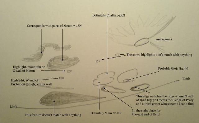
I have used the NASA link in Bill’s post to generate the libration-corrected map (what a magic tool!), scaled it to match my sketch which I then overlaid. That’s blown away a lot of the fog and a fair bit of the sketch makes sense now. I’ve uploaded my conclusions. The dark plain right on the limb remains a puzzle however.
 10 December 2019 at 11:22 am #581762
 Dr Paul LeylandParticipant
Hmm, you posted while I was still composing my reply so I didn’t see your annotation.
Either or both of us could be wrong. We can’t both be right.
Paul
10 December 2019 at 11:26 am #581760 Dr Paul LeylandParticipant
I’m now looking at the Virtual Moon Atlas which displays the appearance at specific times and dates — which means that the libration and illumination are depicted realistically.
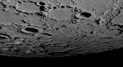
The “Dark feature” is a combination of Peary (closest to the limb), Byrd and Gioja. All of these are well above 80N. The southernmost, Gioja, is at 83.346N; Peary is 88.625N.
Your “dark-floored crater” is Scoresby and the atlas shows its floor in deep shadow at 2019-12-08T22:35Z (my guess at your time of observation). The “craters” between Anaxagoras and Scoresby are Goldschmidt D and a peak for which I have yet to find a name. The pair to the north of Scoresby might be Main and Main A or perhaps Main L. The “very bright floor” and the neighbouring features on your sketch appears to be an extremely eroded crater which does not seem to have been named.
The attached image is a screenshot of the area in question as it appears on the Virtual Moon Atlas for the time and date in question. The red square marks Goldschmidt D
 10 December 2019 at 3:58 pm #581766
 Alan SnookParticipant
I appreciate your take on this Paul. Our different interpretations are certainly a measure of how the appearance of the ground changes hugely with the angle of the Sun. What I’ve done now is transfer my sketch to tracing paper so I can better test the match-up with my downloaded NASA Moon and with your screenshot. If I anchor the sketch at Anaxagoras and adjust the scale to match up the “dark floored crater” with Scoresby, it pushes the limb to the wrong place and the wrong angle. The east end of the “dark feature” is pushed off the disk. Conversely if I scale to match that squashed figure-8 in the sketch to Challis & Main then the limb is spot on. But that leaves me wondering why I didn’t note anything of Scoresby. On the both the virtual Moon and the old-school Hatfield Photographic Atlas it’s a prominent feature! Sun angle again I guess. Your interpretation has the merit of explaining more of the small bright patches.
The tracing paper overlay also suggests the E end of the “dark feature” is due to the crater de Sitter at 80 degrees N but the match is not convincing. Now better informed, I think I need to look out for the next favourable libration and have another go.
-
AuthorPosts
- You must be logged in to reply to this topic.
