- This topic has 6 replies, 3 voices, and was last updated 5 years, 5 months ago by
 David Strange.
-
AuthorPosts
-
18 September 2020 at 1:34 pm #574732
 David StrangeParticipant
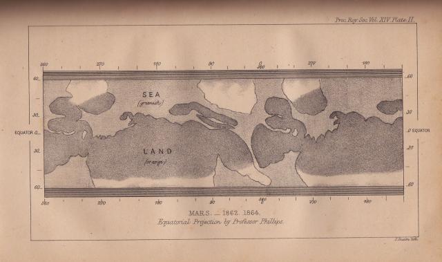
Couldn’t resist a photo of this drawing of Mars dated 1862/64 from NLO archives. It was produced by Prof. Phillips at Oxford who was Lockyer’s mentor. Lockyer was an avid Mars observer and even had a vast flat basin named after him, which appeared on Richard Proctor’s map – Lockyer Land. This was later renamed Hellas by Schiaparelli. There was a lot of water about in those days!
David
Attachments:
18 September 2020 at 9:27 pm #583125Neil Morrison
ParticipantI have a book Lessons in Astronomy by Norman Lockyer first printed in 1868. My edition is the revision of April 1889.
There are two plates in it Page115 paragraph 256 “”Let us begin with Mars .. We give in Plate IX two sketches taken in the year 1862. ,Here at once we see that we have something singularly like Earth. The shaded portions represent water , the lighter ones land , and the bright spot at the top of the drawings is probably snow lying round the south po0le of the planet which was then visible. The upper drawing was made on the 25th september ,the lower one on the 23rd In the upper one a sea is seen on the left , stretching down northwards ; while , joined on to it as the Mediterranean is joined on to the Aatlantic, is a long narrow sea , which widens at its termination. Paragraph 259 Mars not only has land and water and snow ‘but it has clouds and mists, and these have been watched at different times. The land is generally reddish when the planets atmosphere is clear ; this is due to the absorption of the atmosphere, as is the colour of the setting sun with us. The water appears of a greenish tinge.
Paragraph 259a A very curious feature of the surface of Mars was detected in 1877, when the planet made one of its nearest approaches to Earth. the so called “continents” were then seen to be divided into innumerable islands by a network of ” canals”, or long and narrow arms of the seas, some times running almost in a straight line for 3,000 or 4,000 miles. It was on the same occasion that the moons of Mars were discovered by Professor Hall at Washington
There is no credit given as to whom the observer was who made the drawings “The book was prepared as a Science text book for schools. Very interesting to read the ideas of 1862 and what we understand today with our modern in situ exploration of Mars.
18 September 2020 at 9:30 pm #583126Neil Morrison
ParticipantPlate XI
18 September 2020 at 9:34 pm #583127Neil Morrison
Participant19 September 2020 at 9:49 am #583129 David StrangeParticipant
At around the time Lowell’s “Canals on Mars” story was evolving, H.G,Wells was studying biology at the Normal School of Science, apparently he attended a few of Lockyer’s astronomy lectures which no doubt seeded his ideas for “War of the Worlds”.
David
19 September 2020 at 10:10 am #583130 Dr Richard John McKimParticipant
Lockyer was a very good artist and observer, and his drawings of 1862 are the best available, though there are some other good drawings in the literature. The map given by David is also included in the famous book by Flammarion, and it relied quite a lot on the drawings of W.R.Dawes, whose originals I published in the Journal many years ago. I have seen the hand-drawn original coloured version of the Phillips map, but I do not have the copyright permission to post an image of it here. Comparison shows that once again the engraver did not really do the original map justice. Had Schiaparelli found a more sympathetic engraver who could have rendered the famous 1877 drawings in a closer manner to the originals I am sure that the debate about the martian canals would have evolved differently.
22 September 2020 at 10:46 am #583151 David StrangeParticipant
I came across this Mars map that pre-dates Schiaparelli’s from Patrick Moore’s Guide to Mars 1956. Lockyer Land became Hellas, and the Kaiser Sea became Syrtis Major.
David

-
AuthorPosts
- You must be logged in to reply to this topic.
